Desert Aqua-Net  The Shimizu Corporation has already envisioned the Great Man-Made River post-conflict as Dubai-style hydrological flamboyance. Transnational canals crisscross the post-liberation terrain of the Maghreb, delivering not fossil water, which is non-renewable, but seawater to Gaddafi's reservoirs mutated into Herman Sörgel's utopian lakes, on the shores of which are desalination plants powered by Desertec's Apollonian fields. Orbiting these islanded oases like planetesimals, just beyond Magnus Larsson's circumnavigating erg-cathedrals, are crop circles growing saltwater tolerant, drought resistant GM vegetables. Dreams grafted on dreams grafted on dreams grafted on dreams grafted on dreams. The Great Reservoirs of Libya  Here are the five reservoirs of Libya's Great Man-Made River, Muammar Gaddafi's megaproject bringing “fossil water” drawn from aquifers in the desert south to the coastal cities. These are the terminal points of the project's Phase I water pipeline, running roughly through the middle of the country for some 1,200km. Additional pipelines run through the eastern and western parts.  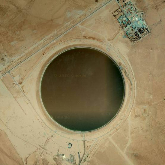   Also check out BLDGBLOG's dispatch from this segment of the Super-Versailles — half a decade ago! (Im)possible Chicago #9  The United Great Lakes is a hydrostate encompassing the entire drainage basin of the Great Lakes plus a chunk of the St. Lawrence River Basin. These territories ceded from Canadian provinces and American states are organized into administrative cantons coterminus with the sub-basins of each individual lake. The capital city is Chicago. The choice of Chicago as the capital was controversial at first, because it had for decades allowed the Illinois and Michigan Canal to wastefully drain water out of the lakes. No one objected once the flow of water was re-reversed, especially since everyone realized it was strategically positioned near the parched city-states of Los Angeles, Las Vegas and Phoenix, their main hydro-export markets. Indeed, Great Lakes freshwater is their main commodity. It is also their only major industry. Gone are the Boeings, the GMs and the Dow Chemicals: they've all either moved to the low-tax pastures of Texas or gone bankrupt. But with unquenchable demand of the petrostate of New Alberta and more distant markets like China, linked via the Mississippi River turned international waterway, the economic impact of their desertion and erasure was minimally negative. Below the city and following its grid system are the cavernous reservoirs of thousands of Mega-Notre-Dames, buttressed with buttressed buttresses, columned and aisled with service passages and emergency tunnels. Jutting out from each one and puncturing the surface are Neo-Gothic spires housing pumping stations, pressure release valves and permanent crew quarters, with the grander ones additionally housing the federal government of the water cartel. Some are quite tall, even reaching the height of the once standing Sears Towers. Not for anything is Chicago now nicknamed The City of Spires. Illinois Tollway Oases  We previously suggested having a picnic in Jackson Park and/or Red Gate Woods while on your Atomic Tour of Chicago's Nuclear Edgelands, but if Jackson Park isn't fringe enough for you and if eating close to a nuclear dumpsite sounds too unappetizing, how about stopping at one of the Illinois Tollway Oases on the city's ring roads? These oases are roadway rest areas whose defining feature is a glass bridge built over the highway they service. Inside are the usual coterie of fast food restaurants, such as McDonald's, Subway and Panda Express. There are seven listed by Illinois Tollway, although the DeKalb Oasis does not have an over-the-road food court. But you can ignore it, because it's way out in the western hinterlands. If this website is to be believed, these oases are apparently vernacular to the Chicagoland area. They are found nowhere else — except, of course, for the Glass House in Vinita, Oklahama, and a couple of examples in England, which, if the same site is again to be believed, were “inspired by the Oases in Chicago.”  In reviewing David Lawrence's Food on the Move: The Extraordinary World of the Motorway Service Area, Will Wiles briefly describes one of these English oases, writing: “At Charnock Richard on the M6, Charles Forte — the missing link in British fast food between milk bars and McDonald's — built an Italian-style futurist glass bridge over the motorway containing a high-class grill restaurant where diners could watch the traffic passing underneath, a kind of automotive dinner-theatre.” If you're looking for a peculiar venue for a public viewing of David Cronenberg's Crash, try a tollway oasis. Then again, if there's an actual crash screened through the glass, the whole thing will come off as some sort of grotesque affectation. For easy trip planning, we've mapped all these oases (green picnic placemarks; regular green for DeKalb Oasis) in relation to Site A/Plot M (the southern nuclear placemark). Next door with the atomic placemark is Argonne National Laboratory, the direct successor of Site A and (can we say this?) descendant of the Chicago arm of the Manhattan Project. The northern nuclear placemark is Zion Nuclear Power Station, retired in 1998 but scheduled for decontamination and dismantlement in a year or two. Perhaps it's interesting to note that parts of Chain Reaction was filmed at Argonne. That movie, starring Keanu Reeves, is perhaps the only cinematic treatment of bubble fusion, a hypothesized form of nuclear fusion using sonoluminescence. Keanu aside and not forgetting that Fermilab is nearby, one wonders what other cutting edge nuclear physics are being done along the fringe. Site A / Plot M 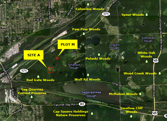 A tour of Chicago's nuclear fringe definitely wouldn't be complete without a stop at the Palos Forest Preserves located just outside the city to the southwest. Inside and accessible only via hiking trails are the 19-acre area known as Site A and the 150x140-foot area known as Plot M, respectively the site of the world's first nuclear reactors and radioactive waste dumping ground. Of course, the first nuclear reactor (Chicago Pile-1, or CP-1) was located on the campus of the University of Chicago. But just a few months after its first nuclear chain reaction in December 1942, CP-1 was dismantled and reconstructed on Site A. It was then renamed CP-2. A second reactor, known as Chicago Pile-3 (CP-3), was also built. In 1950, this reactor was renamed CP-3' (CP-3 prime) when it was rebuilt with a new design. Also built on Site A were about 35 buildings housing laboratories, dormitories, a cafeteria, dog kennels and a lead foundry.  According to the Department of Energy, all research programs at these facilities ended in 1954 and moved 3 miles to the east to a new complex, the Argonne National Laboratory. While the fuel for both reactors and heavy water were taken somewhere else, all buildings on Site A were torn down and, along with most of the equipment, buried where they stood. An excavation approximately 100 feet across and 40 feet deep was prepared between the two reactors. The reactors themselves were approximately 180 feet apart. The 800-ton, concrete-filled, shell of the CP-3 reactor was buried by excavating around it on three sides and detonating strategically placed explosives in the earthen “pedestal” supporting it. The reactor shell rolled and ended upside down in the excavation. The concrete shield of CP-2 was demolished and pushed into the same excavation. The buildings that housed the reactors were demolished and placed in the excavation. The excavation was then backfilled, leveled, and landscaped. The top of the CP-3 reactor shield is approximately 23 feet below ground surface; rubble and building debris fill the excavation both laterally and vertically to within a few feet of the surface. Placed at the approximate location of the burial site is a large engraved (head)stone describing the historical significance of Site A.  Located 1,500 feet north of Site A is Plot M. There, radioactive waste and radioactively contaminated laboratory articles generated from research activities at Site A were buried.  The method of disposal sounds rather crude in comparison to today's vast subterranean nuclear sarcophagi but nevertheless underscores the ongoing uncertainties over the safety of more modern burial strategies — or any of them, in fact. Apparently both solid and liquid waste was buried from 1944 through 1946. Liquid wastes were disposed in intact containers, which may have subsequently been breached. Through 1948, waste was buried in 6-foot deep trenches and covered with soil to minimize radiation release; beginning in May 1948 burial took place in steel bins. The steel bins were removed in 1949 in a search for some missing uranium-235, which was subsequently found. Instead of reburying the bins, they were shipped off site for disposal; the waste buried in trenches was allowed to remain in place. Records of items placed in Plot M are incomplete, but known items include animal carcasses, building debris, clothing, contaminated equipment, air filters, paper, and other radioactive and hazardous materials. Dumping at Plot M stopped in 1949, and for a few years was covered with soil and grass, which weren't much protection against water infiltration and seepage. Then in 1956: [A]n inverted concrete box was constructed over the entire burial plot. The concrete walls of the box are 18 inches thick and extend 8 feet into the ground. A 1-foot-thick concrete slab was poured over the entire disposal area. The purpose of the concrete barrier is to prevent excavation of the site and to impede the flow of water through the buried radioactive materials. The concrete slab was covered with about 2 feet of soil [and] grass was planted. Interestingly, the DOE does not mention how and where contaminated material were buried during the years when Plot M had already been decommissioned but Site A was still in operation. Just as at Site A, there's a small stone monument briefly describing past top secret activities. Situated as it is atop a gently sloping mound entombing radioactive waste (a malformed Mt. Parnasus, if you will) and surrounded by pastoral landscaping, one half expects finding an additional inscription, which reads: Et in Arcadia ego. It's interesting to see that where the marker assures visitors that the area poses no danger to them, the word “NO” has been chiseled out by vandals. Perhaps it's a hint that all warning signs are bound to fail, not just the signal they carry but the physical sign itself. No matter how many far-forward scenarios have been taken into count and design for in countless ideas competitions (not to mention those ideas competitions for ideas competitions), potentially dangerous landscapes, even lethal ones, will always be attractive destinations. The tourists will come in their CLUI buses regardless of the danger. And the “atomic priesthood” will have its schisms and periods of iconoclasm, when delirious, chisel-happy monks will rebel against the text and rampage through their irradiated basilicas.  But in the meantime, you can have a picnic near Plot M. Sunday in the Park with Chicago's Cold War Missile Defense Shield  During the height of the Cold War, anti-aircraft missile batteries surrounded many of the major population centers in the United States. Built under the Project Nike program, these rings of military bases formed defense shields against a nuclear attack from Soviet long-range bombers. At the beginning of the program, they carried missiles with conventional warheads, but in later years, they were equipped with missiles capable of carrying nuclear warheads with yields ranging from 2 to 30 kilotons. While detonating a nuclear bomb so close to a city like Los Angeles and New York might sound like it would defeat the purpose of protecting them from such a blast, bear in mind that these Nike batteries were literally the last line of defense. Getting just a singe also seems to be a more preferable outcome than total nuclear annihilation. But exactly how many missiles were fitted with a nuclear warhead and at which sites seem to be a matter of state secret.  Chicago had a total of 23 batteries — the most among the Nike program cities. Each one was typically divided into two separate parcels of land. At the Launch Area, the missiles were stored in underground bunkers and brought up to the surface using an elevator and a rail system. Located a short distance away, the Battery Control Area contained the radar and computer equipment. Since each site was typically manned by a large crew of at least 100 personnel, there were recreational facilities, crew quarters and other support facilities attached to either the launch or control area. Otherwise they would have been located at a separate third area.  As can be seen from the map above, most of the sites were built on the urban fringes of the city and away from densely populated areas. A couple were even located in the boondocks of northern Indiana. But what's really interesting about these Chicago emplacements (and what really piqued our interest in the very first place) is that three of them were inserted into prime parkland area along the shores of Lake Michigan. The launch area of Site C-03, for instance, was built on Belmont Harbor; its control area was on Montrose Harbor a little further to the north. Just a few yards away from its arsenal of nuclear-capable missiles were high-rise lakefront apartments. One wonders if residents in those buildings regularly spied on the missiles preening upwards on their launchers during test runs. Surely they must have been treated to the spectacle of a simulated nuclear armageddon.  Another battery, Site C-40, was built on the northern end of Burnham Park, near McCormick Place and Soldier Field. The third, Site C-41, was located in the similarly genteel surroundings of Jackson Park, the very same park designed by Frederick Law Olmsted and Calvert Vaux and in an earlier era hosted Daniel Burnham's White City during the World's Columbian Exposition. It's interesting to think that in the backyard of the Museum of Science of Industry, students from the nearby University of Chicago might have taken leisurely strolls among picturesque lagoons and arcadian meadows while soldiers, in their restricted enclosures, hurriedly scampered about during a readiness drill, the sounds of birds twittering and frolicking mashed up with alarms blaring. Closer to the lake, people threw frisbees around while radar towers looming above them tracked the skies for any incoming apocalypse.  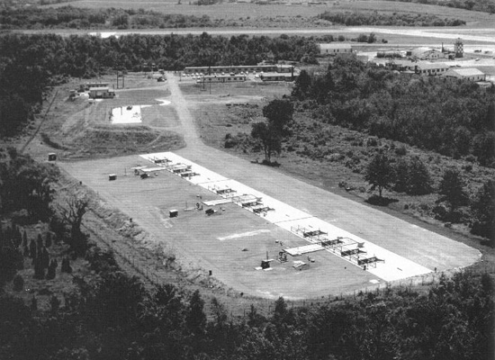 All structures at the three lakefront sites have long been demolished and cleared away. Most of the other sites also have had their buildings razed and their underground bunkers filled in. Post-Nike conversions have varied through the years, and have included a police shooting range, a golf course, parking lots and industrial developments. A popular conversion seems to be turning them into “Nike Parks” or “Patriot's Parks”. There's not much left to see, in other words. One of the better documented sites in its ruin state is C-84. Before a shopping mall was plopped down on top, the National Park Service sent some of its awesome HABS/HAER surveyors in 1992 to take some photographs. One imagines urban explorers lamenting at the loss of such a pleasure ground. 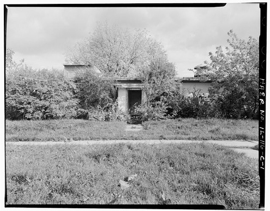   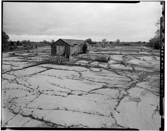 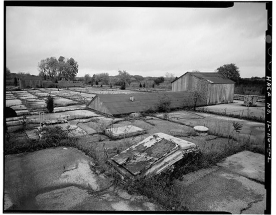  Fortunately for the dark tourists, ruin pornographers and CLUI junkies, there are still some residual traces worth your time. For instance, some concrete slabs and building foundations remain at the launcher area of Site C-44, located at Wolf Lake in the southeastern corner of the city.  To see a sizable collection of buildings and radar towers still intact, you'd have to go to Site C-47 in Indiana. The control area, now a Blast Camp paintball venue, still have some of its radar towers. All the buildings at the launcher area are still standing, though this parcel of the site is private property. 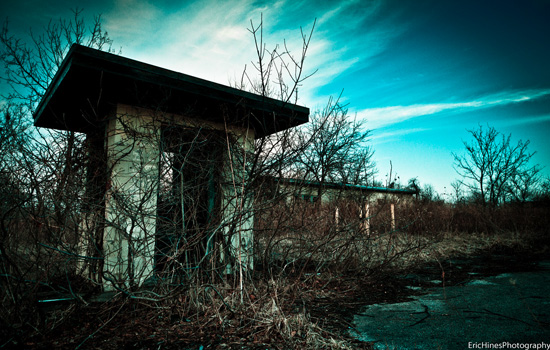 Add in a “Nike Park” and a “Patriot's Park” to the itinerary plus a stop at the C-84 shopping mall and even a picnic in Jackson Park, and you have the making of an interesting Sunday outing perambulating the city's edgelands. It'd be like re-tracing some spectral pilgrimage route encircling the city, perhaps in tangent to the same arcs and loops which decades ago some military inspector, while island hopping from one nuclear arsenal to another, had inscribed into the landscape with his irradiated body. And who knows, maybe you'll also be soaking in minute amounts of radiation at each way station, in which case your own infinitesimally irradiated body will be leaving a trail of energetic breadcrumbs. It'll be an atomic tour of Chicago's Cold War missile defense shield. Buy Plum Island Now and again, we check out what's being offered up for sale by the Office for Real Property Utilization and Disposal. It's mostly to rekindle our childhood fantasies of living in a lighthouse — our own hermitage in an eternally fog-blanketed solitary garden. In the past, we had fixated on this quaint Second Empire sea cottage and this oil platform with micronational ambitions. There always seems to be a couple for sale, perhaps because more modern, GPS-augmented maritime navigation systems have created redundancies. And indeed there are four retired lighthouses on the auction block at the moment, or soon will be: all are definite beauties. A more interesting property, however, is Plum Island, home of Plum Island Animal Disease Center, or “America's first line of defense against foreign animal diseases.” 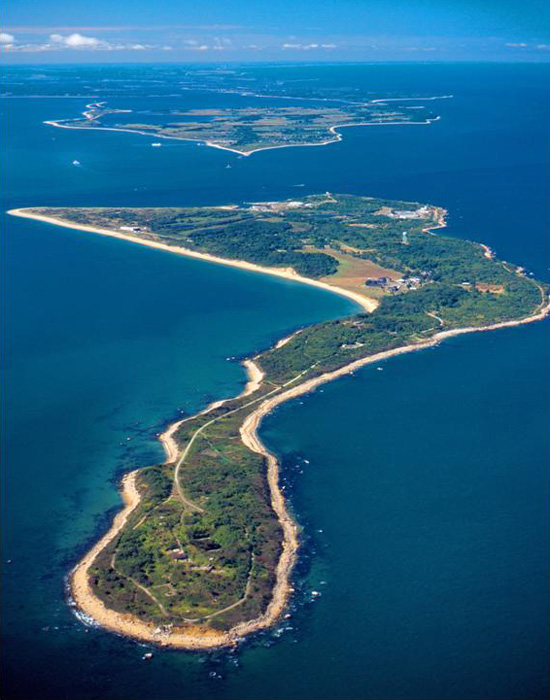 The island and everything on it is up for sale. That includes buildings that once housed or currently store the pathogens responsible for foot-and-mouth disease, hog cholera, African swine fever and various others that invariable delight fantasists, conspiracy theorists and apocalypse aficionados. To ensure easy access for the new owners, marine ferries will also be included in the sale. We've always hoped that the government would donate the research facilities, or lease them for $1/year, to Richard Pell so that he can house and expand his PostNatural History Museum. | ||


No comments:
Post a Comment