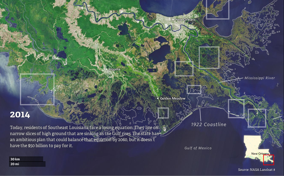
Watch how Louisiana's coastline has vanished over the last 80 years
Over the last 80 years, Louisiana has lost nearly 2,000 square miles of coastland — land that has simply vanished into the Gulf of Mexico. And much, much more land is likely to disappear in the years ahead unless major changes are made.
That's the subject of a terrific new investigation from Bob Marshall of The Lens and Brian Jacobs and Al Shaw of ProPublica. You should absolutely go read their entire piece (and check out all of their excellent visuals), but I've made a slider image out of two key maps to highlight the very basic change at play here:

And over the past century, various human activities have disrupted this ecosystem. After the Great Flood of 1927, the US Army Corps of Engineers built up a series of levees along the Mississippi that controlled springtime flooding but also blocked sediment from washing down the river and replenishing the delta.
At the same time, the Louisiana coast became a major source of oil and gas during the 20th century. That meant two things. Energy companies dredged thousands of miles of canals through the wetlands to transport equipment through — and those canals allowed shoreline to crumble and saltwater to seep in, killing off plants. Meanwhile, some scientists argue that the land itself has sunk after companies extracted oil and gas from underground wells.
The ProPublica/Lens piece is a vivid and detailed exploration of these dynamics (though I'd add one more factor — the nutria, an invasive rodent species, is also helping destroy the wetlands). Add it up, and the state now loses some 16 square miles of land each year. That can have all sorts of economic impacts — Louisiana's multimillion-dollar shrimp and crab fisheries depend on wetlands as nursery areas, for one. And the loss of land leaves New Orleans and other cities even more exposed to flooding during severe storms.
Global sea levels are currently rising 3.2 millimeters per year, on average. But the pace has been much faster in parts of Louisiana, because the activities mentioned above that are causing to land to sink — sea levels are rising 9.2 millimeters per year near Grand Isle, La.
And if sea level rise accelerates in the decades ahead, as many scientists expect it will, then southeast Louisiana could end up one of the hardest-hit areas. Below is a map by Louisiana State University's Mike Blum showing what the state's coastline could look like in 2100 in the worst-case scenarios:
/cdn0.vox-cdn.com/uploads/chorus_asset/file/676582/i-2ff-7d9-b-18__1_.0.jpg)
Now, the scenario in this map isn't inevitable. There's still a range of projections for future sea-level rise — this is just one of them, albeit one that dramatically underscores how vulnerable the region is. What's more, Louisiana policymakers have unveiled an extensive plan for coastal restoration (it would include revamping the system of levees so as to allow flooding to replenish the delta), which could at least help slow the sinking. The problem? It would cost tens of billions of dollars and is still far from fully funded.
You should definitely read the full ProPublica/Lens piece for the full story on Louisiana's land loss. And here's a great Q&A with the authors.
That's the subject of a terrific new investigation from Bob Marshall of The Lens and Brian Jacobs and Al Shaw of ProPublica. You should absolutely go read their entire piece (and check out all of their excellent visuals), but I've made a slider image out of two key maps to highlight the very basic change at play here:
Slide your cursor over the map to see the change (Propublica/The Lens)
It's worth noting that this mostly isn't a story about global warming and sea-level rise — at least not yet. The land in southeast Louisiana was built up over thousands of years from sediment washed down by the Mississippi River and anchored by plant life in the marshes and wetlands. Without this replenishing, the soil would simply sink into the Gulf of Mexico.And over the past century, various human activities have disrupted this ecosystem. After the Great Flood of 1927, the US Army Corps of Engineers built up a series of levees along the Mississippi that controlled springtime flooding but also blocked sediment from washing down the river and replenishing the delta.
At the same time, the Louisiana coast became a major source of oil and gas during the 20th century. That meant two things. Energy companies dredged thousands of miles of canals through the wetlands to transport equipment through — and those canals allowed shoreline to crumble and saltwater to seep in, killing off plants. Meanwhile, some scientists argue that the land itself has sunk after companies extracted oil and gas from underground wells.
The ProPublica/Lens piece is a vivid and detailed exploration of these dynamics (though I'd add one more factor — the nutria, an invasive rodent species, is also helping destroy the wetlands). Add it up, and the state now loses some 16 square miles of land each year. That can have all sorts of economic impacts — Louisiana's multimillion-dollar shrimp and crab fisheries depend on wetlands as nursery areas, for one. And the loss of land leaves New Orleans and other cities even more exposed to flooding during severe storms.
So what might Louisiana's coast look like in the future?
This is where global warming enters the picture. As the world heats up and the ice caps melt, sea levels are slowly rising. So far, this has been a minor contributor to Louisiana's vanishing coastline. But it's expected to become a much bigger factor in the future.Global sea levels are currently rising 3.2 millimeters per year, on average. But the pace has been much faster in parts of Louisiana, because the activities mentioned above that are causing to land to sink — sea levels are rising 9.2 millimeters per year near Grand Isle, La.
And if sea level rise accelerates in the decades ahead, as many scientists expect it will, then southeast Louisiana could end up one of the hardest-hit areas. Below is a map by Louisiana State University's Mike Blum showing what the state's coastline could look like in 2100 in the worst-case scenarios:
Now, the scenario in this map isn't inevitable. There's still a range of projections for future sea-level rise — this is just one of them, albeit one that dramatically underscores how vulnerable the region is. What's more, Louisiana policymakers have unveiled an extensive plan for coastal restoration (it would include revamping the system of levees so as to allow flooding to replenish the delta), which could at least help slow the sinking. The problem? It would cost tens of billions of dollars and is still far from fully funded.
You should definitely read the full ProPublica/Lens piece for the full story on Louisiana's land loss. And here's a great Q&A with the authors.
What is sea-level rise?
Global warming has a few major effects on the oceans. As water gets warmer, it expands. And, as glaciers and ice caps in places like Greenland and Antarctica melt, they add water to the ocean. That all causes sea levels to go up.
Global average sea levels have risen roughly 19 centimeters (7.5 inches) since the 19th century, after 2,000 years of relatively little change. The rate of sea-level rise has continued to increase in recent decades:


High emissions: If greenhouse-gas emissions keep growing, however, sea-level rise gets even more drastic. The IPCC is currently predicting up to 1 meter of sea-level rise (3.3 feet) by century's end if emissions keep growing unchecked. And the oceans would continue to rise for centuries thereafter.
Effects: Rising sea levels are expected to increase the risk of flooding, storm surges, and property damage in coastal cities and regions. One 2013 study in Nature Climate Change estimated that average annual losses from flooding in the world's biggest coastal cities could rise from $6 billion per year today to $1 trillion per year by 2050. Cities could build flood defenses — levees, pumps, and movable barriers — but at a cost of tens of billions of dollars per year.
Uneven rise: Sea levels also won't rise evenly everywhere. In some regions the land is actually sinking, due to sediment erosion or freshwater pumping. In other regions, strong wind and ocean currents can warp the waters and affect local sea levels. The melting of the giant ice caps will also have odd gravitational effects.
That's why, for example, New York and New Jersey could experience sea-level rise that's 8 inches higher than the global average this century.
Global average sea levels have risen roughly 19 centimeters (7.5 inches) since the 19th century, after 2,000 years of relatively little change. The rate of sea-level rise has continued to increase in recent decades:

IPCC
Exactly how high sea levels will rise in the future depends on how greenhouse-gas emissions rise and how the world warms. This IPCC chart shows future projections under a low-emissions scenario (in blue) and high-emissions scenario (in red):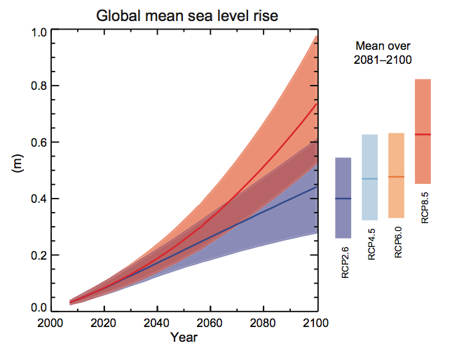
IPCC
Low emissions: We've already warmed the planet enough to heat and expand the oceans and lock in some melting of land ice. So, even if we do reduce emissions, we can still expect some additional sea-level rise in the decades ahead — possibly half a meter (or 1.6 feet) by the end of the century, and continuing thereafter.High emissions: If greenhouse-gas emissions keep growing, however, sea-level rise gets even more drastic. The IPCC is currently predicting up to 1 meter of sea-level rise (3.3 feet) by century's end if emissions keep growing unchecked. And the oceans would continue to rise for centuries thereafter.
Effects: Rising sea levels are expected to increase the risk of flooding, storm surges, and property damage in coastal cities and regions. One 2013 study in Nature Climate Change estimated that average annual losses from flooding in the world's biggest coastal cities could rise from $6 billion per year today to $1 trillion per year by 2050. Cities could build flood defenses — levees, pumps, and movable barriers — but at a cost of tens of billions of dollars per year.
Uneven rise: Sea levels also won't rise evenly everywhere. In some regions the land is actually sinking, due to sediment erosion or freshwater pumping. In other regions, strong wind and ocean currents can warp the waters and affect local sea levels. The melting of the giant ice caps will also have odd gravitational effects.
That's why, for example, New York and New Jersey could experience sea-level rise that's 8 inches higher than the global average this century.
Read This
- Scientists found the origins of the Ebola outbreak — by tracking its mutations
- Scientists agree: Coffee naps are better than coffee or naps alone
- The very scary word in Putin's new statement on the Ukraine crisis
- Playboy's guide to catcalling is actually really great
- One in six French people say they support ISIS
No comments:
Post a Comment